


FLASH NEWS
NASA reveals rare image of cloud vortexes swirling over the Atlantic Ocean

2025-07-04 08:09:35 / MISTERE&KURIOZITETE
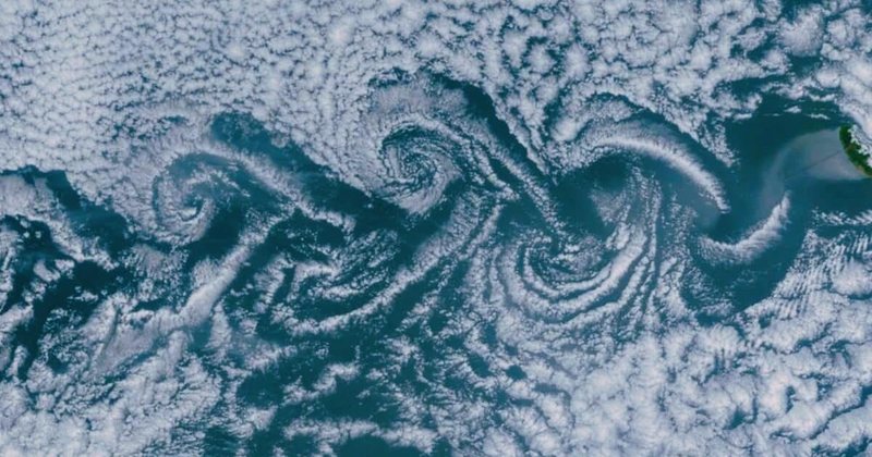
A stunning 2015 satellite image has captured a rare meteorological phenomenon known as von Kármán vortices moving from several islands in the Atlantic Ocean. These moving cloud patterns were visible in a photo taken by NASA's Terra satellite on May 20, 2015, covering an area of about 260,000 square miles. The image includes vortices emanating from Madeira, the Canary Islands, and several other locations. The event is one of the largest and most widespread cases of von Kármán vortices ever observed in the ocean, adding a fascinating scientific understanding of wind behavior and atmospheric disturbances.
NASA's Earth Observatory also highlighted similar vortices in its visual reports, with a particular focus on the Canary Islands and their role in this natural phenomenon. The study by NASA's Earth Observatory provides in-depth analysis of vortices formed by geographic points and how these cloud vortices give researchers insight into the atmospheric dynamics of regions around the globe. One of the most notable occurrences of these vortices was over the Canary Islands, where they were more intense than usual. These vortices are important to meteorologists and climatologists who study how air currents interact with different landforms, especially islands and mountain ranges.
Von Kármán vortices are a rare but interesting weather phenomenon that occurs when wind flows over a land mass, causing a disturbance in the air that forms rotating cloud patterns. As the air hits the obstacle, a series of alternating vortices form on either side of the obstacle. These vortices propagate downstream, often becoming visible when clouds become trapped in the spiraling air currents. They appear as rows of spirals, with each pair of vortices rotating in opposite directions. Vortices can vary in size and intensity, but when they occur over areas with high mountains or islands, they can be particularly impressive.
In this satellite image taken by NASA's Terra satellite, multiple groups of vortices are visible rotating from at least six different islands in the Atlantic. Each group of vortices is visible as swirling trails of clouds, with the vortices near Madeira being the most prominent. This phenomenon provides valuable insight into the dynamics of the atmosphere and how localized winds interact with natural geographic features. By studying these vortices, scientists can improve their understanding of the forces at play in Earth's atmosphere, which could help predict weather patterns and improve climate models.
The formation of von Kármán vortices is driven by the flow of air over an obstacle, usually a land mass or mountain. When the wind encounters a physical barrier, the air splits and spirals into alternating vortices that form on the downwind side of the obstacle. The vortices consist of rotating air masses traveling in the direction of the current, with cloud patterns helping to make them visible. These vortex patterns are often most pronounced in regions where strong winds and high mountains create ideal conditions for vortices to form.
One of the reasons why the vortices near Madeira and the Canary Islands are so striking in the 2015 satellite image is the unique combination of geography and climate in these regions. Madeira and the Canary Islands have giant peaks and are located in an area with persistent trade winds that can create strong, regular disturbances in the atmosphere. This makes them an ideal place to see von Kármán vortices, which are often visible in cloud formations that appear as a result of air rotation. These clouds serve as a visual marker of disturbed air currents, allowing scientists and observers to appreciate the intricacies of atmospheric dynamics.
Among the best places to observe von Kármán vortices are the Madeira Archipelago and the Canary Islands. Both regions are strategically located in the Atlantic Ocean, with high mountain peaks and unique weather patterns that make them prime candidates for this phenomenon. Madeira, located in the north of the Canary Islands, is particularly famous for the intensity and clarity of the vortices that form around it. The detailed vortices patterns near Madeira in the satellite image highlight the extraordinary strength of the wind flows in this area and the complex atmospheric processes involved.
The Canary Islands, which consist of seven main islands, also exhibit distinct vortices, although not as pronounced as those seen near Madeira. The vortices emanating from islands such as La Palma, Tenerife, and Gran Canaria are visible but less defined. However, the vortices formed around La Gomera and Tenerife interfere with each other, almost completely canceling out their patterns. The islands' high volcanic peaks contribute to these disturbances, while the surrounding tropical climate helps the vortices to be visible when clouds get caught in the swirling air currents.
Happening now...


America may withdraw from Europe, but not from SPAK
Nga Gentian Gaba
ideas


top


Alfa recipes


TRENDING 


services
- POLICE129
- STREET POLICE126
- AMBULANCE112
- FIREFIGHTER128